Toroweap, Arizona: Betrayal On The Lava Falls Route
By Nickolay Todorov
As the 80s Toyota 4X4 hydroplanes sideways across the sea of mud, Mark and I giggle stupidly. We have lost control over the vehicle and we are waiting for destiny’s mercy. How things had changed. Only a few seconds before we were screaming in ecstasy as we barged at 70mph through the flooded “Primitive Road,” as the sign half a mile back had called it. “Proceed at your own risk,” it added.
Outlined behind us against the vermillion cliffs of Zion is Colorado City, the remote polygamist town of excommunicated Mormons and a frequent host to FBI raids. If the truck topples over, we will have to trudge back and search for help in one of those massive dark houses we just passed, like unsuspecting characters in a horror movie.
Luckily, the stars are aligned in the right way. The truck loses momentum before it climbs over the shoulder and hits dry dirt. We scream obscenities, laugh and give each other hi-fives. Then we jump into the mud, lock the hubs and proceed, with the comforting growl of the four-wheel drive, across seventy miles of mud, dirt and rocks towards Toroweap, perched on the northern rim of the Grand Canyon.
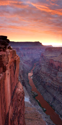
The Toroweap Outlook is one of the most remote spots in one of the most remote parts of the country. The Arizona strip, the last mapped area in the lower 48, stretches along the northern edge of the Grand Canyon, from Lake Mead on the West to Glen Canyon on the East. Toward the middle, removed seventy miles from the nearest maintained road, stands the Toroweap Outlook, the most awe-inspiring vantage point of the Grand Canyon, with a head-spinning three-thousand-foot drop to the Colorado River. The spot, equipped with a small camping site, is visited by less than 1,000 people per year. That's roughly .002 percent of the five million at Grand Canyon Village and the half-million at North Rim each year.
As we come within several miles of the road’s end, we start to hit some rough terrain. A giant full moon rises to the East. We establish camp at the deserted site and set on foot to find the rim.
I thank God for the bright moon for keeping us from walking right over the edge, a massive flat boulder that forms the ledge on which we crawl and peek into a kilometer of black abyss. Down there, flickering like a firefly, is the bonfire of rafters resting on the banks of the Colorado. Over the next two days, this is the only sign of life we will encounter.
March nights in a tent in the high desert are glacial. Thick gusts of wind threaten to blow us over while we sleep. We hear them coming from miles away in five-minute intervals throughout the night. They push the tent to one side and vanish, leaving only silence and the smell of dust. I am grateful when the sun arrives, even though at 7 a.m. the temperature barely touches forty.
The reason we chose to come at this chilly time of the year was our next destination: a descent to the Colorado so precarious that it is not even considered a trail. The Lava Falls Rout, a 55% grade, dirt-and-gravel slide is the steepest and fastest plunge from the Grand Canyon rim to the Colorado River.
At the bottom awaits a series of intense river rapids called Lava Falls. In the summer, the temperatures can hit 120 degrees, in the winter snow blocks the way, and in the fall the lightning and flashfloods threaten constantly. The best time to attempt this route is from late March to early May.
From the campsite, we drive to the trailhead on a nasty road; when it rains, the road gets flooded and even a 4X4 cannot pass.
The Ranger’s log warned matter-of-factly: “Lava Falls Route is not for the faint of heart. Be fully prepared for self-rescue.” There were sporadic entries of people who had gone down, just a handful per week.
We dive into the Canyon nervous because of provisions. The steep course requires a balance between a sufficient amount of water and food and the light weight we need to keep. It is a gamble either way. For similar weight considerations, we opt not to take the tent.
Our path is indicated by cairns piled every twenty feet. We slide over crushed volcanic rock at a precipitous angle. My feet can not find steady surface, so I jog in the steeper parts, protecting my ankles from a potential sprain or, God forbid, break; a broken ankle here could mean death.
Page 1 of 2
Next Page
All contents copyright
©2006 Pology Magazine. Unauthorized use of any
content is strictly prohibited. |